Not supported at the present. Use new OziTrackConverter to convert tracks and points.
Simple converter for OziExplorer calibration files, tracks and points
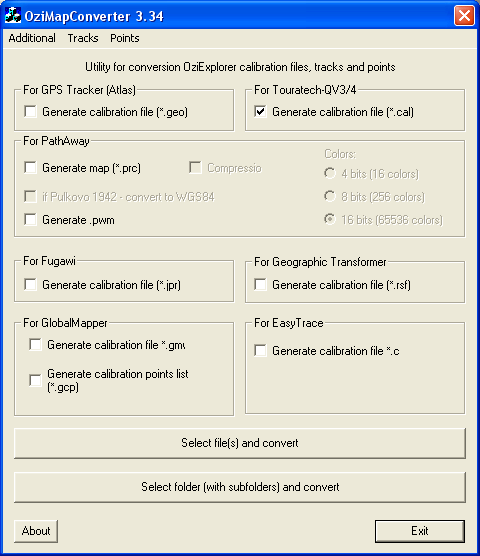
Can do:
- Convert NMEA tracks (*.nmea) to GoogleEarth tracks (*.kml) and OziExplorer tracks(*.plt)
- Convert MapSource tracks (*.mps) to GoogleEarth tracks (*.kml) and OziExplorer tracks (*.plt)
- Convert OziExplorer tracks (*.plt) to OziExplorer route (*.rte)
- Convert OziExplorer tracks to .gpx и .kml (GoogleEarth) and vise versa
- Converts OziExplorer points to .kml (GoogleEarth) and vise versa
- Generate calibration files (*.cal) for Touratech-QV3 (Windows)
- Generate calibration files (*.jpr) for Fugawi (Windows)
- Generate calibration files (*.geo) for GPS Tracker (Atlas) (PalmOS)
- Generate map (*.prc) for PathAway (PalmOS). If map is *.ozf, convert it with OziExplorer before.
- Generate calibration files (*.rsf) for Geographic Transformer (Windows)
- Generate calibration files (*.gcp и *.gmw) для программы Global Mapper (Windows)
- Resample maps OziExplorer with calibration points recalculating
Download: OziMapConverter 3.34 (521
kb)
If dont start, download and install (visual
studio lib (2,6 Mb))
Support of the program is carried out on an irregular basis, in process of a finding by the author of a free time for this purpose :-)
Version 3.34
Fixed: conversion tracks and points from
GoogleEarth (*.kml) to
tracks and points
OziExplorer (*.plt).
Added conversion NMEA
tracks (*.nmea) to GoogleEarth (*.kml)
and OziExplorer (*.plt).
Minor bugs fixed
Version 3.2 - Improved: Conversion from GoogleEarth (*.kml)
Version 3.1 - Added MapSource (*.mps) to GoogleEarth tracks (*.kml) and OziExplorer (*.plt) conversion
Version 3.0 - Improved: Conversion speed OziExplorer (*.plt) -> GoogleEarth (*.kml), OziExplorer (*.plt) -> *.gpx
Version 2.97 - Improved: Conversion from GoogleEarth (*.kml) to OziExplorer routes (*.rte) conversion
Version 2.97 - Improved: OziExplorer tracks (*.plt) to OziExplorer routes (*.rte) conversion
Version 2.96 - Added OziExplorer tracks (*.plt) to OziExplorer routes (*.rte) conversion
Version 2.95 - Added GoogleEarth tracks (*.kml) to OziExplorer routes (*.rte) conversion
Version 2.94 - Improved: Conversion from GoogleEarth (*.kml),
Version 2.93 - Added: Conversion OziExplorer points (*.wpt) to GoogleEarth points (*.kml). And *.kml -> *.wpt
Version 2.92 - minor improvements
Version 2.91 - Added support Lisboa (Portugal) datum
Version 2.87 - Fixed: conversion for EasyTrace. Added: Conversion GoogleEarth (*.kml) -> OziExplorer (*.plt)
Version 2.86 - Fixed: UTM conversion. Added: conversion for EasyTrace
Version 2.85 - Improved: Conversion OziExplorer (*.plt) -> GoogleEarth (*.kml), OziExplorer (*.plt) -> *.gpx
Version 2.83 - Fixed: multiselection tracks
Version 2.82 - Added: Conversion OziExplorer (*.plt) -> *.gpx. Improved: Conversion OziExplorer (*.plt) -> GoogleEarth (*.kml)
Version 2.81 - Added support datum Potsdam Rauenberg, projection Swiss Grid and British National Grid.
Version 2.79 - Added OziExplorer tracks (*.plt) to GoogleEarth tracks (*.kml) conversion
Version 2.78 - Bug fixed in Touratech->OziExplorer conversion
Version 2.77 - Minor bug fixes in: OziExplorer ->Touratech conversion, Touratech->OziExplorer conversion and GPX-track-> OziExplorer track conversion
Version 2.76 - Added support datum Campo Inchauspe(Argentina). Export to Global Mapper now in projection "Geographic(Latitude/Longitude)"
Version 2.75 - Converting to Pathaway is improved
Version 2.74 - More accurate conversion for Geographic Transformer. Added: Extraction calibration infomation from BSB (*.kap) files and conversion to Touratech (*.cal) and OziExplorer (*.map) files (converting to bitmap possible with this tool: libbsb ). Added: Conversion Touratech calibration files (*.cal) to OziExplorer calibration files (*.map)
Version 2.72. More accurate conversion European 1950 datum